
Today is the 10th anniversary of Navigation Day in Japan, started in 2014 by Zenrin, the map company that helped create the world’s first in-car GPS in the Mazda Eunos Cosmo. The date of July 1 was chosen to coincide with the summer Obon holidays, a popular time for travelers to go long distances.
As much as we love our classic cars, there probably aren’t many of us who use period correct navigation methods. These days, it’s increasingly tempting to rely on navigation systems even if you’re familiar with the roads, thanks to features like real-time traffic updates. How do you find your way around when you’re an older car? Do you use a smartphone app, a separate GPS device like a Garmin, paper maps? Mega props if you carry a Thomas Guide.
How do you navigate when driving your JNC?
The most entertaining comment by next week will receive a prize. Scroll down to see the winner of last week’s QotW, “Which historic auto industry figure would you visit if you could time travel?“.

You chose a wide range of historical figures hailing from many different countries and time periods, a real Bill and Ted’s phone booth of the automotive world.
From Europe we have BlitzPig‘s pick of Enzo Ferrari, Lakdasa‘s choice of Andre Citroen, and Fred Langille‘s selection of Karl Benz. Hans Ledwinka of Tatra got two nominations, from Alan and Brett. Japan’s Jujiro Matsuda, founder of Mazda, also go two nods, from Franxou and Jidoshaojisan. And last but not least, from the list of American icons Legacy-san named Walter Chrysler, Ian G. picked the Dodge Bros, and Fred chose Henry Ford.
At the end of the day though, this is JNC, so the winner this week was Dillon, who would love to go back in time and hang with Jiro Kono, the project lead of the Toyota 2000GT:
I would want to visit during the time that Toyota and Yamaha began their works in the 2000gt. What a time to be alive when you have masters of Sewing Machines, Motorcycles, and Woodwind instruments, to build Japan’s million dollar super-car.
Omedetou, your comment has earned you a set of decals from the JNC Shop!


Since the S-Cargo hasn’t any sort of built-in navigation in it, we use our phone’s GPS. However, the big problem was how. Driving back from Canada where we picked it up in Montreal, my wife held the phone and it’s power cord while I squinted and looked when needed. After our trip home to West Virginia, I knew a better system had to be found. Fortunately, the cigarette lighter provided the power through a cord but, a mount … temporary of course needed to be found and, good old e-bay provided one that had the phone hang from the rear-view mirror. This has worked for every show we’ve been to. Its at eyelevel so, I can drive and note how we travel as we scroll along on the app. This is just the way to do it electronically. Prior to this, normal driving was as challenge since my road perspective being thrown off due to RHD (in the beginning … now, there is no effect at all) and, according to Doug DeMauro (sp?) the rear-view mirrors … interior was fine but, the outside ones (which were not balanced on the front fenders, thank God!) did wiggle until I found an adjustment screw (that Doug DIDN’T find) on the bottom of the mirror while I was repainting. No more wiggles! Still, sometimes I feel like a giraffe craning my neck to correctly ascertain traffic properly. Good thing the little van is soooo noticeable and people do see it on the highway. So, driving it on long trips isn’t too bad …keeping to the slow lane and letting rubberneckers go by is par for the course. Otherwise, driving the van isn’t too much of a changeover … there’s no radio at present to distract me so, driving isn’t too hard. There’s alot more work to do before a radio is installed though but, it’s coming up soon.
I still have no solution worked out for my 83 Subaru, but when I had to press my almost-JNC-aged 2000 Impreza back into daily service, I knew I wanted something with CarPlay to show me the traffic. I picked out a Pioneer single-DIN deck with a pop-out-flip-up screen in honor of its 90s heritage, and it looks non-descript enough when retracted. For period-correctness, it does still have in the top-dash spot the late-90s Subaru compass pack, which also uses an onboard barometer to drive an altimiter, for all my vertical navigation needs.
Nothing fancy but on the the NB2 Miata (stock CD player) and the MKI MR2 (aftermarket removeable face), I use an FM Transmitter plugged into the lighter socket, USB to the cell phone, move the wires out of the way so I can shift gears properly and use the Waze.app.
The icon is either an F1 car or the Red Jeep (sometimes I use Waze on the Element) and a British female voice so I can remain calm while driving.
As I loath looking at screens of any kind when driving, if I am going to a destination I am unfamiliar with I will look up the route on my PC the night before, then write out a strip chart, much like used for running a rally, go over it and commit it to memory. Then I will have it in the car with me to refer to as necessary when on the trip.
It’s a system that has worked for me for decades.
I just look out the window!
That too!!
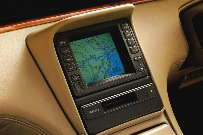
I gently nudge a precision cut and radiant piece of walnut, and it rotates 90 degrees in a slow, oil-dampened motion. An elegant aesthetic design and enduring marvel of robust Late Bubble Era engineering, my LS430’s center console ashtray is thus ready to accept my iPhone, a device at odds to its host’s timeless utility, grace, and facilitation of legitimate freedom. I tune the Mark Levinson to some nice jazz, perhaps a bit of Eric Satie or Debussy, and glide into traffic like a swan alighting a placid lake, distant V8 woofle a pleasing and solitary reminder that I am operating a complex machine composed of countless thousands of intricately networking parts. A dulcet, disembodied female voice whispers gentle captainship from somewhere in the uncanny valley, and all is at ease within my soul.
Then a brodozer cuts me off and the phone flops out onto the floor and wedges itself underneath the seat track, the low-res factory GPS screen looking on disapprovingly as if to say, “really?”
If its to an area I am not sure of I usually check the maps and note down the landmarks, it helps when proper directions are posted by the authorities. When ever I think I missed a turn or think I’m lost I turn to my phone and check on Google Maps. But nowadays a lot of people use android systems that they fix on their cars and use the Google Maps on them which is much easier than attaching your phone to the dashboard and finding power, plus it comes with the ability to play music on Spotify / USB through your car speakers.
In my case and still pending the installation of the radio with cassette, the only electronics in my Isuzu is my phone that brings together the navigation and music/radio/streaming/communication functions connected to an adapter for power. simple, efficient, and without any type of support, those that are attached to the ventilation grilles end up breaking them, a big problem that I had to solve, supports from the windshield end up being an interference and others that can be attached to the torpedo do not convince me of their stability . I guess I’m too old school and prefer to keep it simple.
The thing about navigation is I absolutely LOVE getting lost!
The best places I found were all stumbled upon during a random ride, for I am a recent nostalgic car convert here, my NC is not roadworthy yet and I mostly ride motorcycle for fun. Nothing can beat getting lost way out there on some never before seen road, stopping for a drink of water, popping the phone out and just asking it to take me home, then listening for the instructions via the comm in the helmet. Simple as that, no need for a display!
There was a thing I was very curious about: Tripper, by Royal Enfield, it was made to look like a normal retro bike clock, it connected to the rider’s phone and only gave the direction of the next turn and its arrow filled up as you came closer of that turn. Simple and minimalistic, but apparently the app was poorly done, overheated phones and then the chip shortage made the actual clock too expensive to make, which is sad. Great idea, not enough development time.
I am sure we could fit such a system to many of our cars without ruining its character. The idea is very neat, and it could be made in many other ways, in a reflexion on the bottom of the windscreen, on a little pod on the A-pillar or suspended from the center rear view mirror, a gadget on the centerstack near the radio, even a small dongle clipped to the vents? And a better app.
I guess now my 7th gen Celica may have made it to nostalgic status since it began production in July 1999 (I’m unsure of the exact date).
Until a few years ago I still printed out MapQuest or Google Maps directions. (Cue the commercials about turning into your parents). But these days, I just use the Apple Maps app on my phone. Pretty boring.
I am hoping to pick up a 1988 Celica All-Trac in the near future and get back to a proper nostalgic. If everything works out, maybe I should become a member of AAA and order a paper TripTik for any trips I take in it, and my wife can give rally style co-driver navigation directions.
Hmm, sounds like a good idea for a weekend trip this fall. 🙂
I free my mind and my arse follows
When I first started driving in the 70s I did it pretty much by general direction, roadway signage, and memory of visual cues like buildings or businesses after the first trip. Then I moved on to regional maps from gas stations and AAA if I was taking an out of state trip. When I started to travel for work, MapQuest had arrived on the PC and I used it to print directions, which I then stuck to my dash. This eventually morphed into Google/Apple Maps on my iPhone. Early on I never saw the use of in-car navigation systems since I always had my iPhone with me. Now when I get into my car Apple Maps automictically tells me how long it will take to drive to work/home. It is nothing short of amazing how quickly the technology has progressed.